 The
Ecuadorian Pacific coast and western lowlands locally known as "la
costa" is formed by the following densely populated provinces, from
north to south: Esmeraldas, Manabí, Los Ríos, Guayas and El Oro. The
Coast covers about 70'000 km, less than one third of the surface of
Ecuador, but 50 % of the population live in this region, mainly in and
around the city of Guayaquil, the pulsing and modern major business and
economic center and main port of Ecuador. The region’s climate varies from hot and arid on the
Santa Elena peninsula to hot and humid in the
alluvial plains and interiors between Esmeraldas and the gulf of
Guayaquil. The average temperature is 24°C (18ºC to 30ºC); the climate
is very much influenced by the ocean currents El Niño (warm) and
Humboldt (cold). The
Ecuadorian Pacific coast and western lowlands locally known as "la
costa" is formed by the following densely populated provinces, from
north to south: Esmeraldas, Manabí, Los Ríos, Guayas and El Oro. The
Coast covers about 70'000 km, less than one third of the surface of
Ecuador, but 50 % of the population live in this region, mainly in and
around the city of Guayaquil, the pulsing and modern major business and
economic center and main port of Ecuador. The region’s climate varies from hot and arid on the
Santa Elena peninsula to hot and humid in the
alluvial plains and interiors between Esmeraldas and the gulf of
Guayaquil. The average temperature is 24°C (18ºC to 30ºC); the climate
is very much influenced by the ocean currents El Niño (warm) and
Humboldt (cold).
On the coast, the dry season runs from about June to
December. Temperatures drop to about 16ºC and it is often overcast with
a damp mist (garua) settling in and the sun can disappear for three
months at a time. A little way inland the garua breaks up and you can
have bright sunshine. The pattern is roughly the same as in the
Galapagos except the garua starts earlier on the mainland and finishes
later. |
|
January to June the temperatures warms up, days are bright and sunny
with an occasional heavy rain. This is the best time of year along the
beach. The El Niño current can heavily modify the coastal area weather,
a strong current flowing in January from the Gulf of Panama making the
air and water temperatures soar. The wind comes around the north and it
rains. The El Niño in 1998 caused major problems as roads and bridges
being destroyed and whole towns cut off for months. The heavy rains
washed the Canoa forest into the ocean.
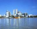 Guayaquil is Ecuador’s largest city, principle port
and the economic center of Ecuador. The city is3 located near the head
of the Guayaquil Gulf on the Guayas River. Most of the nations import
and export trade pass through the city's deepwater port. Major
industries in Guayaquil include shrimp fishing, petroleum refining, food
processing, machinery manufacturing, and the manufacturing of consumer
goods. Guayaquil is Ecuador’s largest city, principle port
and the economic center of Ecuador. The city is3 located near the head
of the Guayaquil Gulf on the Guayas River. Most of the nations import
and export trade pass through the city's deepwater port. Major
industries in Guayaquil include shrimp fishing, petroleum refining, food
processing, machinery manufacturing, and the manufacturing of consumer
goods.
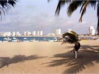
Santa Elena peninsula near
Salinas is known for its world-class yacht harbor and deep-sea fishing.
In contrast the traditional fishermen can be seen sailing the same
waters in balsa rafts, catching fish for the local population. There are
several comfortable hotels to choose from and the long; twin crescent
shaped beaches makes the area popular for national tourism.
 Esmeraldas the Green Province, as it is called,
is located on the country’s northwestern coast. Here, the temperature
ranges from 21 to 25 degrees Celcius. Its main attraction are the
beaches in the southern part of the province as well as the
Cayapas-Mataje Ecological Reserve to the north. The city of Esmeraldas,
the provinces capital, is one of Ecuador’s main ports and terminal for
the nation's petroleum pipeline. Esmeraldas the Green Province, as it is called,
is located on the country’s northwestern coast. Here, the temperature
ranges from 21 to 25 degrees Celcius. Its main attraction are the
beaches in the southern part of the province as well as the
Cayapas-Mataje Ecological Reserve to the north. The city of Esmeraldas,
the provinces capital, is one of Ecuador’s main ports and terminal for
the nation's petroleum pipeline. |